
CRG Launches Free Ops Planner for Public Safety Agencies
Critical Response Group (CRG) releases free Ops Planner, enabling public safety agencies nationwide to build emergency action and special event plans on CRG's mapping foundation.

Press Release Disclaimer: This is a press release distributed through the XPR Media network. It has not been independently verified by our newsroom.

Critical Response Group Launches Free Ops Planner for Public Safety Agencies Nationwide
PR Newswire
HAMILTON, N.J., Sept. 8, 2026
New no-cost capability enables first responders to build emergency action and special event plans directly on CRG’s nationwide mapping foundation
HAMILTON, N.J., Sept. 8, 2026 /PRNewswire/ — Critical Response Group (CRG) today announced the nationwide launch of Ops Planner, a new operational planning capability available at no cost to public safety agencies in communities where Collaborative Response Graphics® (CRGs) have been deployed.
For more than a decade, CRG has worked to establish a common operating picture for emergency response by creating accurate, field-verified maps and integrating them into the 911, CAD, GIS, emergency management and response platforms agencies already rely on. More than 100,000 CRGs have now been produced nationwide, providing responders with a standardized geographic reference across thousands of facilities and communities.
Ops Planner extends that common operating picture into the planning process.
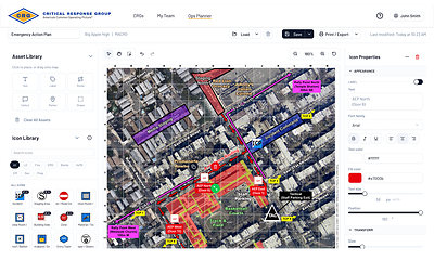
Police, fire, EMS, 911, SWAT and emergency management teams can use their existing CRGs as the foundation for emergency action plans, special event operations and other pre-incident planning—without purchasing an additional planning platform.
Agencies can place incident command posts, staging areas, casualty collection and triage locations, reunification sites, access and traffic control points, operational zones, perimeters and sectors directly on the map, while also creating routes and adding other agency-defined operational resources. These elements mirror the types of information used to organize complex incident and event operations.
“For years, our focus has been on ensuring that everyone responding to an incident is working from the same accurate map,” said Mike Rodgers, Founder and CEO of Critical Response Group. “Ops Planner carries that same principle upstream into preparedness. Agencies can now plan an event, develop a site specific emergency action plan or coordinate a multi-agency operation using the same common operating picture responders will have available when the plan is activated.”
The platform supports planning across a broad range of public safety operations, from active-threat and mass-casualty incidents to stadium events, large public gatherings and other pre-planned operations. Operational plans may incorporate command locations, security zones, staging, evacuation, reunification, and emergency vehicle routes, access control, traffic management and mutual-aid coordination.
The technology behind Ops Planner was used earlier this summer to support public safety planning surrounding FIFA-related events in New Jersey, demonstrating its application in complex, multi-agency event environments.
Making the capability free to public safety was a deliberate decision.
“Communities across the country have already invested in building and field-verifying CRGs, and public safety agencies have incorporated those maps into their response systems and operating procedures,” Rodgers said. “Ops Planner gives them a way to derive even greater operational value from that investment. If the common operating picture already exists, agencies should be able to plan from it.”
That approach also addresses a longstanding challenge in emergency preparedness: plans, maps and response systems are often developed independently of one another. Ops Planner allows agencies to build operational plans on the same responder-centric mapping foundation that can be shared across dispatch, command and responding disciplines.
Ops Planner is available now at no cost to eligible public safety agencies wherever CRGs have been deployed.
About Critical Response Group
Critical Response Group (CRG) provides field-verified geospatial intelligence, operational awareness technology and interoperable mapping solutions for public safety. CRG has produced more than 100,000 responder-ready maps nationwide and supports thousands of public safety agencies through an ecosystem of more than 200 technology and operational partners.
Collaborative Response Graphics® are developed specifically for emergency response through on-site validation and are delivered in interoperable formats that integrate with CAD, 911, GIS, emergency management, situational awareness and command-and-control platforms. Together, CRG’s mapping and operational awareness capabilities help agencies maintain a consistent common operating picture across disciplines, jurisdictions and phases of emergency management.
For more information, visit CRGPlans.com.
Media Contact
Michael Mehlhorn
Critical Response Group
mmehlhorn@crgplans.com
www.crgplans.com
 View original content to download multimedia:https://www.prnewswire.com/news-releases/critical-response-group-launches-free-ops-planner-for-public-safety-agencies-nationwide-302872029.html
SOURCE Critical Response Group


