Drone Surveying Emerges as Key Tool for Safer, Faster Infrastructure Planning
Just another WordPress site

Press Release Disclaimer: This is a press release distributed through the XPR Media network. It has not been independently verified by our newsroom.


Mandurah, WA – July 29, 2026 – Drone surveying is becoming an increasingly important tool for infrastructure planning, as project teams seek faster, safer and more accurate ways to capture site data before major works begin.
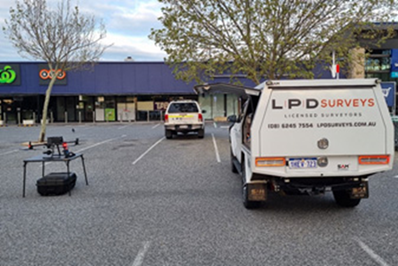
Across construction, mining, land development and civil infrastructure, UAV aerial surveys are helping planners, engineers and contractors build a clearer picture of project sites. For organisations looking for a land surveyor in Perth, the shift reflects a broader move toward digital survey data, visual reporting and repeatable site intelligence.
LPD Surveys, a Western Australian surveying business in Mandurah, provides land, engineering, mining, infrastructure, UAV aerial survey and 3D reality capture services across the state. The company operates from Perth, Mandurah, Kalgoorlie and Bridgetown, supporting metropolitan, regional and remote projects.
Jake Lampard, founding director and senior licensed surveyor at LPD Surveys, said drone surveying is changing how early-stage infrastructure decisions are made. “Drone surveying gives project teams a clearer and faster understanding of a site before major decisions are locked in. For infrastructure planning, that matters because teams need reliable information about terrain, access, services, levels, constraints and surrounding conditions. UAV data can reduce the need for repeated manual access to active or difficult areas, while producing visual records that engineers, contractors, developers and clients can interpret quickly.”
LPD Surveys’ UAV aerial survey services include drone mapping, aerial imagery, inspection photography, site progress images, geo-referenced orthomosaic maps, 3D models, exportable contours, point clouds and volume calculations. These outputs can support a site survey in Perth by giving stakeholders a detailed, measurable view of a project area.
The global market reflects this rising demand. Fact.MR estimates the drone surveying market at USD 1.97 billion in 2025, with projected growth to USD 11.49 billion by 2035. A separate drone land surveying forecast also estimates growth from USD 1.5 billion in 2026 to USD 12.6 billion by 2036, driven by construction, energy, mining, agriculture, oil and gas, and property development applications.
Safety remains a major factor in adoption. In Australia, the Civil Aviation Safety Authority says drones must generally not fly higher than 120 metres above ground level and must remain at least 30 metres away from people. LPD Surveys says its CASA certification, Remote Operators Certificate capability, experienced surveyors and UAV drone pilots help ensure aerial survey work is carried out in line with safety and aviation requirements.
For developers and subdivision surveyors in Perth, drone surveying can also assist with site context, contour information, development planning and visual reporting across large or changing land parcels.
The company’s Perth surveyor also helps with construction set-out, feature and contour surveys, mining work, infrastructure projects and digital capture services. Its UAV deliverables may include:
• Site progress imagery and geo-referenced maps
• 3D models with exportable contours
• Aerial imagery overlaid with feature and contour surveys
• High-resolution inspection photography
• 3D surface DTM and volume calculations
• Survey-accurate photogrammetry and reality models
Lampard said the technology is especially useful when paired with professional survey oversight. “Infrastructure projects are under pressure to move quickly, but speed should not come at the expense of reliable data,” he said. “Working with licensed surveyors in Perth means UAV outputs can be connected to survey knowledge, project control and the realities of construction delivery. That combination helps clients make better decisions earlier.”
For property surveyors in Perth, UAV technology adds another layer of site visibility that can support both early investigations and ongoing project documentation.
About Company:
LPD Surveys provides land surveying, engineering and construction surveying, mining and infrastructure surveying, land development and subdivision support, UAV aerial surveys and 3D reality capture services across Western Australia. Visit https://lpdsurveys.com.au/
Media Contact
Company Name: LPD Surveys
Contact Person: Jake Lampard
Email: Send Email
Phone: (08) 6245 7554
Address:45 Delawney St
City: Perth, Balcatta
State: WA
Country: Australia
Website: https://lpdsurveys.com.au/